The Fujiwhara effect: The Perfect Storm Over Spain That Doesn’t Relent
Spain Braces for UNRELENTING Fury: Is This the WOR...
Spain is currently battling relentless heavy rainfall, gale-force winds, and a barrage of weather alerts as Storm Joseph, a deep low-pressure system exhibiting unusual behavior, continues its assault. This isn't your garden-variety storm; Joseph is being significantly impacted by a rare phenomenon called the Fujiwhara effect, making an already challenging situation even more dire.
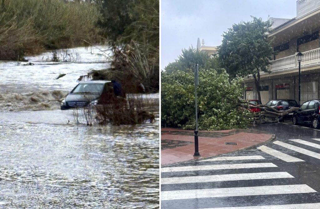
This uncommon meteorological event, coupled with a powerful atmospheric river, is essentially trapping intense precipitation over large swathes of the country. The result? Escalating risks of flooding, overflowing rivers, and widespread disruptions to daily life. I saw firsthand the impact driving near Madrid yesterday; roads were rivers, and the wind was strong enough to shake my car. The State Meteorological Agency (AEMET) has understandably issued orange alerts for a huge portion of the country.
The consequences are already being felt. Schools have been forced to close, provincial roads and bridges have been blocked by emergency services, and even a simple walk down the street has become genuinely hazardous. Tragically, a 31-year-old woman in Torremolinos lost her life on Tuesday after high winds uprooted a palm tree. A sobering reminder of the power of nature.
So, what exactly *is* the Fujiwhara effect? Well, it occurs when two or more nearby low-pressure systems get close enough to influence each other. They can start to orbit each other, or, in this case, significantly slow each other's movement. Storm Joseph, already a potent system packing intense rain bands, is interacting with another nearby low-pressure area. This interaction is causing it to move sluggishly, almost becoming stationary, constantly pulling in moist Atlantic air and essentially regenerating rain fronts. Instead of a quick in-and-out storm, we're seeing persistent rainfall over the same areas.
Experts tell us that this effect was particularly strong from Tuesday night into Wednesday, leading to hours of unrelenting downpours and record rainfall totals in some regions. This unusual dynamic has amplified the storm’s impact considerably, making it much harder for the system to dissipate or move away from Spain. It’s like the storm is stuck in a meteorological rut, unfortunately.
And if that wasn't enough, we also have a potent atmospheric river in play. Think of it as a narrow but incredibly moisture-rich airflow originating from subtropical and tropical regions over the Atlantic. They are often described as "motorways of humidity," and they can transport truly vast amounts of water vapor across the seas. In this case, the river is continuously feeding Joseph and its associated fronts, resulting in highly efficient condensation as the moisture slams into the storm systems and Spain’s varied terrain.
Aemet has issued alerts across all autonomous communities for multiple hazards. Rain warnings remain in effect for Andalucia and Castilla-La Mancha, while wind alerts affect a wide area, including Andalucia, Baleares, and Madrid. Snow alerts are also in place for many regions, from Aragon to Madrid. Coastal wave warnings are covering much of the Spanish coastline. The situation remains dynamic, and residents are urged to stay informed and heed the warnings issued by authorities.
By Adam Woodward • Published: 28 Jan 2026 • 9:25 • 2 minutes read
Comments
Please sign in with Google to post a comment
No comments yet. Be the first to comment!